
Court Judgments, Historical Documents Validate ‘Controversial’ Akwa Ibom Map Law (Part 1)
By Ofonime Honesty/ Uko Etim
Months of investigation have revealed facts about the Akwa Ibom Map Establishment Law 2023, enacted by the Akwa Ibom State House of Assembly and signed by former Governor Udom Emmanuel. The law was a product of legal judgments dating back to the colonial era and extending to present times.
A new map was NOT drawn, according to findings.
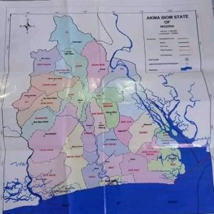
Akwa Ibom State
Akwa Ibom State, created on September 23, 1987, by the military junta of Head of State General Ibrahim Babangida, is located in the South-South geopolitical zone of Nigeria. It borders Cross River State to the east, Rivers State and Abia State to the west and northwest, and the Atlantic Ocean to the south.
Akwa Ibom takes its name from the Qua Iboe River, which bisects the state before flowing into the Bight of Bonny.
It was split from Cross River State in 1987 and has 31 local government areas, with Uyo as its capital. The state is the 30th largest in area and the 15th most populous, with an estimated population of nearly 5.5 million.
Modern-day Akwa Ibom State is inhabited by various ethnic groups, primarily the closely related Ibibio, Annang, and Oro peoples.
In the pre-colonial period, the area was divided into various city-states before becoming a British protectorate in 1884. After Nigeria’s independence in 1960, the area was part of the Eastern Region until 1967, when it became part of the South-Eastern State. The area was later renamed Cross River State, and Akwa Ibom was eventually carved out in 1987.
The Akwa Ibom State Map Establishment Law 2023
On April 14, 2023, the Akwa Ibom State House of Assembly passed a bill for a “law to provide a map for the state and other matters connected therewith.”
The law, titled the Akwa Ibom State Map Establishment Law 2023, took effect on April 13, 2023.
The development followed a report by the Joint Committee on Lands and Housing, Boundary and Conflict Resolution, and Local Government and Chieftaincy Affairs, presented by its then Chairman, Sir Udo Kierian Akpan, who represented Oruk Anam State Constituency.
According to its sponsor, Hon. David Lawrence, who represented Eket State Constituency, the bill aimed to “reduce agitations and communal conflicts, enhance and promote development within the mapped-out boundaries, enhance cultural affinities of the people within the boundaries, make for easy identification and placements, and assist in the proper identification and allocation of resources domiciled in the component units.”
The Bill also recommended that all government white papers and judgments on boundary issues across the state be taken into consideration and implemented without delay.
Co-sponsors of the Bill were Sir Udo Kierian Akpan (Oruk Anam), Barr. Aniefiok Dennis Akpan (Etinan), Otuekong Nse Essien (ONNA), Elder Mark Esset (Nsit Atai), Hon. Victor Ekwere (Mkpat Enin), Hon. Uduak Odudoh (Ikot Abasi/Eastern Obolo), Barr. Otobong Bob (Nsit Ubium), Obong Godwin Ekpo (Ibiono Ibom), and Hon. KufreAbasi Edidem (Itu). Only Edidem and Bob remain as members of the Assembly; others have either assumed other political offices or gone into private endeavours.
Aniekan Bassey, Speaker of the Assembly when the bill was passed, now represents Akwa Ibom North East (Uyo) Senatorial District in the Nigerian Senate.
The Law was endorsed by the immediate past Governor, Udom Emmanuel, in the twilight of his administration in 2023.
Mixed Reactions
The law triggered debates, tension, and crisis in the state. Killings and destruction of property ensued in many parts of the state.
While some parts of the state welcomed the development, others stoutly opposed it.
His Royal Majesty Edidem E. C. D. Abia, Paramount Ruler of Eket Local Government Area, a chartered accountant by training, former Accountant General, and Permanent Secretary of the defunct South Eastern State, did not mince words in endorsing the law.
“There was no map; we couldn’t have persisted that way. What was circulated in the past was not an official map. It was something someone drew, and people used it, and that map created a lot of problems,” he said in an interaction with newsmen in his palace.
“The map that some people refuse to accept, they will accept because the map is based on decided court cases,” he warned.
Also, a forum under the aegis of the Coalition of Aboriginal Coastal Local Government Areas of Eket, Esit Eket, ONNA, Mkpat Enin, and Ikot Abasi endorsed the new law, describing its opposers as ‘purveyors of falsehood.’
A statement signed by the President General of the Ekid Nation, Dr. Samuel Udonsak, warned against fanning the embers of crisis over the mapping of the state.
The coalition insisted that “Akwa Ibom State had never been mapped before. The ownership of the entire coastline of Akwa Ibom State has been determined in perpetuity by various apex courts, some as far back as 1918.”
It further claimed, “It is only Ekid people that can tell the true boundary of Ibeno LGA. For we gave them land, and when they needed a place to bury their dead, we gave them additional land. When they needed to build the native court, it was the Ekid people who gave them more land. Even in recent memory, the former Deputy Governor, Sen. (Engr.) Chris Ekpenyong, still alive, negotiated for us to cede our land for them to build their secretariat. It is incorrect to say that Ibeno was not created without a boundary. The seven villages that made up Ibeno LGA at its creation had a defined boundary.”
The coalition also claimed that “ExxonMobil’s Qua Iboe Terminal (QIT) is situated on Ekid land. This is incontrovertible. The courts have affirmed this. When the land for QIT extension was needed, it was acquired from the Ekid people. There are discussions in the public space on the imminent transfer, sale, or change of ownership. In the absence of a formal discussion with the community, it is imperative to inform any prospective beneficiary that a seamless and hitch-free transfer would include timely engagement with the community.”
But the Oro Youth Movement, a prominent civil rights organization, vowed to oppose the law “with the last drop of our blood.”
The group, in a statement by its National President, Edet Eyo, said it was “surprising that the governor claims Akwa Ibom never had a map before now.”
“The timing and rushed passage of the bill suggest an ulterior motive. The governor (former Governor Udom Emmanuel) seems intent on extending his hometown LGA (ONNA) to the coastline to qualify as a littoral community under the Petroleum Industry Act (2021), thereby accessing host community benefits,” it alleged.
“We will defend our land at all costs,” they warned.
The Ijaw Youth Council also raised an alarm.
IYC National President, Dr. Theophilus Alaye, in a statement in Abuja, alleged that in the past few weeks, neighbouring communities of Eket and Esit Eket have directed physical and verbal threats towards Ibeno.
The IYC said the ‘remapping’ has triggered a crisis in the area.
“We wish to state categorically that this avoidable crisis, created by the proposed remapping engineered by ex-Governor Udom Emmanuel, is producing that unfortunate result of destruction of property and loss of lives in Ijaw communities in the state. It is worthy of note that the people of Eket allocated Ibeno land to themselves.
“These provocative actions have been treated with kid gloves by the governor, and we see it as a move to promote ethnic war between the Ijaw and their neighbours in the state.”
Many individuals, ethnic groups, and organizations equally voiced approval or disapproval of the law.
Related: AKHA Calls For New Map For Akwa Ibom
Governor Eno Urged to Implement Law
The five aboriginal coastal local governments of the state, in October 2024, threatened that they would only support Governor Eno for a second term if he enforced the law.
Speaking on their behalf, a former federal lawmaker, Bassey Dan-Abia, said the areas were being threatened due to the non-implementation of the map.
Dan-Abia noted that the non-implementation of the state’s map has provided a leeway for Ibeno and Eastern Obolo Local Government Areas to lay claims to ancestral lands not originally theirs.
“We are not asking the governor to give us what does not belong to us. From 1916 to date, we have had a series of judgments from courts of competent jurisdiction in our favour declaring that the Stubbs Creek Forest Reserve belongs to Ekid.
“How can we, as stakeholders, convince our people to vote for the governor for his second term if the governor cannot implement the map of the state and make Ibeno know that they don’t own Stubbs Creek Forest Reserve?” he said.
He advocated for justice and the safety of the five aboriginal coastal areas to increase rural development, and promote, and sustain peace in the state.
Legal Suit Dismissed
The Federal High Court sitting in Uyo, on April 30, 2024, dismissed the case instituted by Ibeno, Eastern Obolo, Mbo, and six others, seeking to nullify the law.
In the case, Suit No: FHC/UY/CS/49/2023: The Paramount Ruler of Ibeno & 8 Ors vs. Akwa Ibom State & 15 Others, the plaintiffs challenged the legislative powers of the Akwa Ibom State House of Assembly to legislate on boundaries of local government areas in the state.
The court upheld the defendants’ arguments that the plaintiffs’ suit was a clear case of abuse of court process.
It was also pronounced that while two local government councils—Eastern Obolo and Ibeno—were created for the Andonis scattered in fishing ports throughout the Ikot Abasi, Mkpat Enin, ONNA, and Eket districts, no official map was delineated and gazetted for local governments in the state.
Various Judgments Uphold Map Law
The legal ownership of Ikot Abasi District by the Ibibios was decided at the Supreme Court of Nigeria on March 6, 1926.
The court held that the natural boundary of the Ibibios on the west would be the Opobo (Imo) River and that “this river was their effective boundary.”
The landmark judgment was delivered by Sir Ralph Molyneux Combe, Chief Justice of Nigeria; Sir Frederick Alan van der Meulen, Judge; and Mervin Lawrence Tew, Judge.
In the unanimous ruling, it was held that the Kwa Ibos (Ibibios) never exerted any ownership over land on the west side of the Opobo (Imo) River.
Another challenge against the legal ownership of the Ibibios in the Ikot Abasi district was decided by His Lordship, Justice John Jackson, of the High Court of the Protectorate of Nigeria at Calabar, on February 21, 1945.
In Suit No. C/21/1941, between Ntuenibok and others vs. Douglas MacJaja; later consolidated with Suit No. C/8/1943, between Udom Nse and others vs. Matthew of Okoro Ete, the learned judge ruled as follows: “Where settlements of Andonis (later referred to as Eastern Obolo) have been made east of the Opobo (Imo) River, the uncontradicted evidence is that such occupation was conditional upon the payment by the Andonis to the Ibibios of hundreds of large fish each year.”
The learned judge further held that, though there may have been numerous settlements by the Andonis on the east side of the Opobo (Imo) River, such expansions did not negate the fact that they were living on Ibibio territory.
The Andonis proceeded to the West African Court of Appeal (WACA) in Lagos. The suit, with registration number WAC 2264 – C/21/1941, was before the learned Sir Walter Harrington, Chief Justice of the Gold Coast; Sir John Verity, Chief Justice of Nigeria; and John Alfred Lucie-Smith, Chief Justice of Sierra Leone, on May 5, 1947.
The Lordships dismissed the appeal with costs assessed at fifty-one pounds and eighteen shillings.
A challenge over the legal ownership of the Ibibios of Eket district with the Ibenos was decided in 1916 following litigation between Ibok Etuk Akpan vs. Obongisong Edoho Eket and Ntiero.
This was over the ownership of Stubbs Creek (Akoiyak) and later Okposo. The matter, which was decided at the high court in Calabar, was won by Eket, but Ibeno appealed against the judgment at the West African Court of Appeal (WACA) in Lagos. Following their subsequent loss, Ibeno appealed to the Privy Council in London in 1918 but still lost the appeal.
The Privy Council in London had decided that the entire coastal area from the creek known as Stubbs Creek and the sea, extending from the mouth of the Qua Iboe River eastward along the seashore to Child Point (Okposo II), belongs to present-day Esit Eket and Eket Local Government Areas.
Also, an Order of the now-defunct Eastern Nigerian House of Assembly, as amended in 1955, establishing Stubbs Creek’s Forest Reserve with a map duly delineated, described, and surveyed with beacon stones at strategic locations by the then Eastern Regional Government of Nigeria in 1929, fully established Ekid as owners of Stubbs Creek.
The investigation also revealed that in a suit with registration number No. HEK/108/2002, an Order of Court directed the Surveyor General of Akwa Ibom State to “produce a map of Esit Eket Local Government Area and Akwa Ibom State locating the village Ine Akpautong in its proper position in Esit Eket Local Government Area.”
In cases decided in 1947 and 1948, ONNA obtained judgments (MO/48/1947 and MO/33a/1948) that established Akata as the natural outlet to the sea for ONNA people.
The Cross River State Law No 9 of 1983 in Gazette No 33 on page A87 had listed the villages of Ntafre, Iwud Ukpum, and Ine Ikwe among those in Oniong and Nung Ndem clans, granting Oniong and Nung Ndem clans of ONNA Local Government Area access to the sea.
In the 1995 Judicial Commission of Inquiry Report into the land dispute between Okoroette in Ikot Abasi Local Government Area then and Ikot Ekong, Ikot Akpaden, Ikot Obio Ndoho, etc., in Mkpat Enin Local Government Area, it expressly recommended that the Local Government Boundaries Commission be advised to amend the boundary between Ikot Abasi and Mkpat Enin using the plan of the land in dispute in line with the West African Court of Appeal (WACA) judgment in suit nos. C/21/41 and C/8/43 (consolidated suits between the Ibibio versus Opobo and Andoni). Accordingly, the eight villages of Okoroette, Amadaka, Elile, Kampa, Okoro Mbokho, Iko, Akpabom, and Atabrikang II should thus be included in the Mkpat Enin Local Government Area. Only in the just-concluded mapping of the state has this order been complied with.
The 1990 case (HET/23/77) and its subsequent appeal (2001) saw Ndon Ibotio and Ibotio people win their right over Iko in respect of all Ikot Udobia land, granting them access to the sea.
In 1941, in the celebrated Down Below case, the West African Court of Appeal (WACA) (C/8/1943) awarded all the land on the left bank of the Imo River as far down to the Opobo River to the Qua Iboe River to the Ibibios, which today are the people of Ete.
Findings show that none of the listed judgments was successfully overturned.
Related: Group Faults Akpabio’s Campaign Against Akwa Ibom Map Law
Referencing Historical Document
Perhaps the oldest known literature on the Eket-Ibeno relationship is credited to Percy Amaury Talbot. Chapter 237 of his book, Life in Southern Nigeria, published in 1923, confirmed Ekid’s claim that Ibeno were Andonis who fled slave raids in Bonny and were only given land by the sea bank to settle down.
“Ibeno is, as previously mentioned, recent settlers in this part of the world, whether they are said to have fled from the persecution of the Bonny kings about two hundred years ago.
“On first taking up their abode amid the low-lying lands by the mouth of the Kwa Ibom River, they seemed timid and gentle. Whenever, for instance, an Ibeno hunter killed an elephant—herds of which were and still are fairly plentiful amid the marshlands near Stubbs Creek—the head chief of Afaha Eket, Edogho by name, used to send and demand the tusks.
“At first, the Ibeno submitted, but at length, there came a day when they refused to give them up.
“Now the newcomers (Ibeno) had neither the land nor knowledge necessary for the planting of farms. So they used to bring their smoked fish to exchange for yams, plantains, and other produce in a bush market at the neighbouring village of Urua Ita.
“Thither, therefore, went Edogho Afaha with a strong, well-armed following, and when the Ibeno came to trade as usual, he fell upon them, bound them, and carried them captive to his town.
“After this, he sent a messenger to the head chief of Ibeno, saying, ‘If you do not bring me the tusks you have collected, I will kill the people whom I have taken or sell them as slaves to a far-off tribe.’
“When they heard this, the newcomers were very sad and said: ‘It is better to do as they demand than lose so many of our kin.’ So they brought the tusks and asked for their friends in return, but Edogho answered, ‘First, I told you to bring the tusks only. Now that you have given me all this trouble, you must pay a fine as well.’ Therefore, they paid that also and went back sadly to their town.
“After this, the young men wanted to go out and fight the people of Afaha Eket, but the old men said, ‘No, we cannot do so; for if we fight them, where shall we get fresh chop? We have no farms and are only fisherfolk without so much as a single mimbo grove.’
“So they paid tribute to the Eket people up to the time when the [Colonial] Government came.”
(The second part of this special report will reference more historical documents on the subject matter.)